Paliohora - THE AUSTRALIAN PALIOCHORA-KYTHERA ARCHAEOLOGICAL SURVEY - New Mapping technology
uninews
The University of Sydney
27 September 2002
Changing the way we look at the world

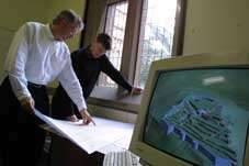
Data detectives: Ian Johnson and Andrew Wilson at work on the TimeMap project
By Alison Handmer
To say that Ian Johnson and Andrew Wilson have the whole world in their hands is only a minor exaggeration. From their archaeological computing laboratory under MacLaurin Hall they, and their team, have masterminded the bringing together of research data from every corner of the globe.
They began with two basic ideas: that the spatial dimension of archaeological evidence could be better explored using geographic information systems (GIS); and that GIS should be time-enabled to more fully realise its potential with historical data. Their work has grown to encompass the mapping of data from the humanities and beyond – data as diverse as radar pictures of unexplored parts of Angkor, archaeological surveys of the island of Kythera, dentistry in rural and regional NSW and multiculturalism in Fairfield.
"By their nature paper maps are static, but all historical disciplines are about showing change through time. Our work allows this using time-enabled GIS," Mr Wilson said.
Their work – assisted by Artem Osmakov, a Russian programmer they found through the Internet – is allowing digital data to be presented, shared, linked and explored in new ways.
Their aim is to develop the techniques and also make them widely available by relying on a combination of their own and publicly available free software and data. Dr Johnson said: "It isn't any single technique that we're using which is unique, it's the integration of many components and their application to humanities data." The duo has dived into collaborative projects around the world, and captured the attention of others just beginning to tap into the possibilities they have uncovered.
Their time-enabled GIS software, TimeMap, was trademarked by the University of Sydney in 1997. Since 1998 they have been collaborating with the Electronic Cultural Atlas Initiative (ECAI), a worldwide consortium of cultural researchers based at the University of California, Berkeley, to develop enabling technology so data may be easily recorded, indexed, linked and accessed in relation to its geographical location. Layer upon layer of information may be built up, then animated or explored through interactive maps.
TimeMap has an immense range of applications. An interactive TimeMap kiosk created for the Museum of Sydney with the help of a SPIRT grant partnership with the Historic Houses Trust and ESRI Australia, helps illustrate the vast potential of the concept.
Mr Wilson said: "Because it's driven by a database, users can make any selections they want. They are free to explore the resource rather than follow pre-determined pathways."
It allows users to explore and interpret maps, images and historical data in new ways. For example, a century ago politicians in Sydney, wishing to demolish parts of the Rocks, spread the message that it was infested with plague. But visitors to the museum can see a different story – mapping the actual sites of infection shows that most outbreaks were clustered further south around Market Street, in proximity to the wharves.
The project has recently developed software providing a map-based search of the Macquarie Net online encyclopaedia. Dr Johnson said: "The TimeMap technology allows interactive maps to be easily embedded in web pages without programming skills or the acquisition of special software." These maps build on resources assembled and made available by other scholars.
"We are making GIS available to the humanities and social sciences," Mr Wilson said. "Through systems like this, historians, classicists or anthropologists without a detailed understanding of mapping software can have access to a wide range of useful information."
Dr Johnson, Mr Wilson and one of their graduate students, Bess Moylan, recently presented a two-day workshop on GIS applications in the humanities on behalf of the e-Humanities Network. Participants ranged from a GIS manager to historians, teachers, a musician and an artist. "Many people are beginning to realise the importance of the spatial component of their research data, and to see that the technology is becoming easily available to exploit this component in interesting ways. Interactive maps are moving from a curiosity to a practical means of delivering educational resources," said Dr Johnson.
In the meantime their commitment to more usual archaeological research continues. As part of the laboratory's ongoing involvement in the Australian Paliochora-Kythera Archaeological Survey (APKAS) on the island of Kythera in Greece, conducted by the Australian Archaeological Institute in Athens, Andrew Wilson recently used the lab's Global Positioning System (GPS) and GIS to record and construct a three-dimensional visualisation of a middle Byzantine fortress discovered during the survey.
The Archaeological Computing Laboratory will soon be moving to the Madsen Building as one of the foundation components of the University's Spatial Science Innovation Unit.
"The TimeMap® project is researching methods for recording, indexing, analysing and delivering Humanities data with spatial and temporal components. We add value to historical and contemporary information by making it accessible on the web through indexed access to scattered resources, interactive maps, timelines and map animation."
For more information on the TimeMap project go to
http://www.timemap.net/
Kythera work:
http://acl.arts.usyd.edu.au/projects/ourprojects/kythera.html